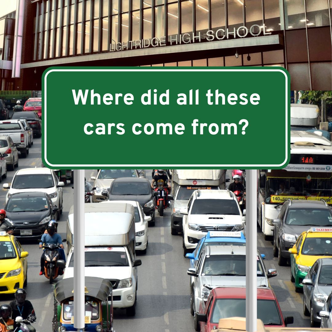
Have you ever wondered why Lightridge has THIS much traffic? Yeah, I mean we have over 2000 students, but do all of them have to be in front of you as you pull into school? Well, good news, I’m about to explain why!
So first of all, I’m going to compare Lightridge High School to Stone Bridge High School in order to contrast student numbers, traffic numbers, and neighborhood design.
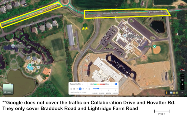
Lightridge High School
Stone Bridge High School
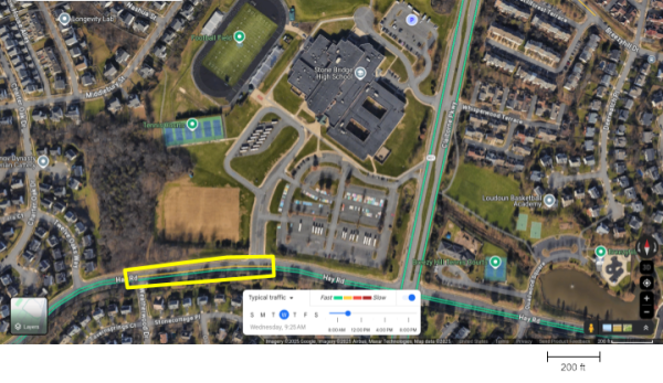
Areas of Traffic Buildup
I measured the traffic on a typical Wednesday morning at 9:25 for both schools. Unfortunately, Google doesn’t consider Collaboration Drive and Hovatter Road as “important” roads and therefore doesn’t calculate traffic volumes for them. However, I trust that most of us have seen the traffic on Collaboration Drive and it is… not pretty.
Lightridge High School clearly has a lot more traffic than Stone Bridge, but this isn’t taking into account the student body. Let’s do that now.
The Students and Their Cars
So first, Stone Bridge High School has 1701 students compared to Lightridge’s 2052. This automatically gives Lightridge a disadvantage as we have to manage traffic for a larger student body size. However, this is not the only reason that Lightridge has a lot of traffic.
Let’s count the number of cars in the parking lot at Lightridge. For Lightridge High School, I used footage taken on April 29th, 2024 as that was the most recent imagery. For Stone Bridge High School, I used footage taken on October 20th, 2021, right after we went back to in-person schooling, because all of the footage since then was either taken after school, during a weekend, or during the summer.
Quick note: I counted all cars for this, including teacher/administrator parking as I am unfamiliar with how Stone Bridge splits up its parking lots.
 Stone Bridge:
Total cars parked = 422
Students = 1701
Students:Car = 4.03:1
Lightridge:
Total cars parked = 617
Students = 2052
Students:Car = 3.33:1
Lightridge has 20.63% more students than Stone Bridge, but has 46.21% more cars than Stone Bridge. This seems a little baffling. Both schools are in the same county and are run by the same board of supervisors. But if we look a little closer at the area surrounding each school, we can start to see why they look so different.
The Neighborhood Around Us
In urban planning, there is a term called a “walkshed.” This represents the distance that people are typically comfortable walking to or from a destination or connecting point (like a bus stop) on a daily basis. This distance is around half a mile radiating out from the central destination. This distance is typically one that people are willing to walk, even if it is cold or rainy because you won’t be in the weather for too long. A half mile takes most people around six to ten minutes. Most people are willing to walk with an umbrella or be in the cold for eight minutes.
There is a map of Lightridge High School’s walkshed below:
There are four markers at the top of the map. That is how many houses are within the walkshed of Lightridge. Four. I can count that on one hand. This means that nearly everybody that goes to this school is not within a comfortable walking distance. If you want to see imagery, there is an option to switch the map to a satellite map in the bottom right corner.
There is a map of Stone Bridge High School’s walkshed below:
This school has many neighborhoods and houses all within a walking distance of the school. There certainly are a lot more houses than I can count on one hand. This means that a significant portion of people can just walk to school rather than driving or taking the bus. This reduces traffic, and also explains the significant difference in the number of cars in the parking lot. If you want to see imagery, there is an option to switch the map to a satellite map in the bottom right corner.
But is it true everywhere?
I’ve given you a very specific example that compares Lightridge with Stone Bridge. Let’s look at another school in order to make sure that it isn’t a fluke. I chose Rock Ridge for this experiment. There aren’t as many homes as Stone Bridge in its walkshed, but certainly a lot more than Lightridge. If you want to see imagery, there is an option to switch the map to a satellite map in the bottom right corner.
Let’s do a count of all the cars there. I used imagery taken on April 16th, 2024. I counted 367 cars in all of the lots, corresponding to the reported school population of 1433. Rock Ridge has less population than both Lightridge and Stone Bridge. If you divide the numbers out, you get 3.9 students per car, slightly less people per car than Stone Bridge, but a lot more than Lightridge.
(I counted both Student and Teacher parking because, as with Stone Bridge, I am unsure as to how they split up their parking lots).
Let’s look at it in a graph:
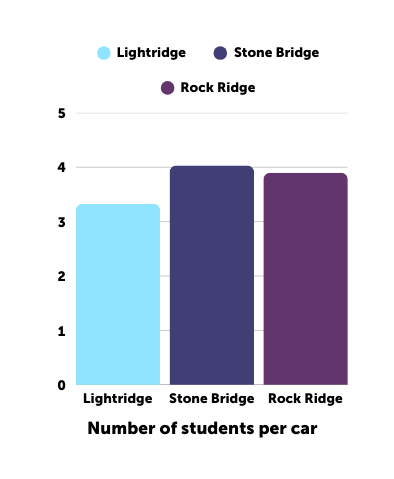 Stone Bridge:
Total cars parked = 422
Students = 1701
Students:Car = 4.03:1
Lightridge:
Total cars parked = 617
Students = 2052
Students:Car = 3.33:1
Rock Ridge:
Total cars parked = 367
Students = 1433
Students”Car = 3.90:1
Rock Ridge has 15.76% less people than Stone Bridge and 13.03% less cars than Stone Bridge. Compared to Lightridge, they have 30.17% less students and 40.52% less cars.
What does all this mean?
It means that we are cursed. Not really, but the development pattern of the neighborhoods in this area probably won’t change anytime soon. That means we’re stuck (at least for the time being) with this traffic. This area is growing really fast, but is growing in a way that doesn’t keep school traffic in mind. No zoning for homes within walking distance to school has been done in recent years.
There is a massive plot of land behind Lightridge that is currently forest, but instead of developing that into homes and upgrading Lightridge Farm Road, development is doubling down on the corner of Braddock Road and Northstar Boulevard, a place that is nowhere near to walking distance from school. This is only going to lead to more overcrowding and more traffic in school.
So sadly, traffic won’t get better within our high school careers, but maybe in the future, we can take lessons that have already been learned by other high schools in our area and apply them to Lightridge, to create a place where there is less school traffic. Or maybe we can apply them to the new high school that is being built only a few miles away.